|
|
|
|

|
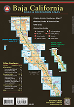
Baja California Road & Recreation Atlas By Benchmark Maps
Highly-detailed landscape maps, beaches, parks,& historic sites. GPS grids and recreation guide.
The first edition Baja California Road & Recreation Atlas showcases the diverse recreation opportunities found along the full length of the Baja California Peninsula. State maps illustrate and describe both states, Baja California & Baja California Sur. Regional maps provide a wider view of the region and Recreation Guides list an array of attractions for trip planning. Landscape Maps� provide the most detail, bringing the peninsula�s rugged terrain into focus with land cover data, shaded relief, and a detailed road network to aid travelers navigating between cities or seeking remote destinations.
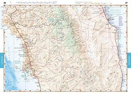
Landscape Maps� Large scale maps with detailed road classifications, points-of-interest, landmarks, elevations Kilometer markers on major highways Page-to-page map overlap, clear legibility National Parks and Wildlife Areas
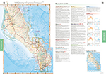
Recreation Guides Regional maps at medium scale illustrate broader views and longer routes Focused maps & listings for La Paz, Los Cabos Corridor, and wineries of Valle de Guadalupe Recreation categories include: Parks, Monuments, Natural Wonders Boating & Fishing Access, Beaches Historic Missions & Ruins Campgrounds & RV Parks